Coolbaugh Nature Area: Another Hidden Michigan Gem from Ron Rademacher
Whenever Ron Rademacher joins Tim Collins on the 95.3 WBCK Morning Show, there’s almost always one thing he gets to at one point. “You take this road, and then that road, and finally you’ll see an old, faded little sign, and you’re there.”
Those old, faded little signs are pretty universal at the out-of-the-way, little-known gems, on the Michigan Backroads. Ron has written at least a half-dozen books to help you find those diamond-in-the-rough sites hidden inside our beautiful state.
One such place is the Coolbough Nature area, northeast of Newago in Brooks Township. It’s a 400-acre nature preserve containing a rare Oak Savanna, ruins of an abandoned agricultural community, trout streams, a 3.5-acre pond, and miles of trails.
Rademacher said, “Oak savannas are extremely rare. This type of forest was fairly common in the early 1800s. Sometimes they were referred to as a dry sand prairie, oak-white pine barrens, or simply an oak opening. The prairie in the Coolbough Nature Area has been restored. White pines and oaks spread their limbs above the open sandy grassland. The diversity of habitats is one of the features of the Coolbough Natural Areas that makes any visit a day of discovery.”
Visitors have the chance to explore ponds and wetlands, hike through white pine and white oak forest, search for butterflies and wildflowers on prairies and barrens, and listen to the bubbling waters of Bigelow and Coolbough Creeks.
But, as usual, Rademacher says there’s another part of Coolbough with more unusual features. “There are ruins of old farms, now little more than foundations remain. Use caution, there are holes and old wells hidden in the undergrowth. Oddly, there is a patch of prickly pear cactus growing near one of the old homesteads.”
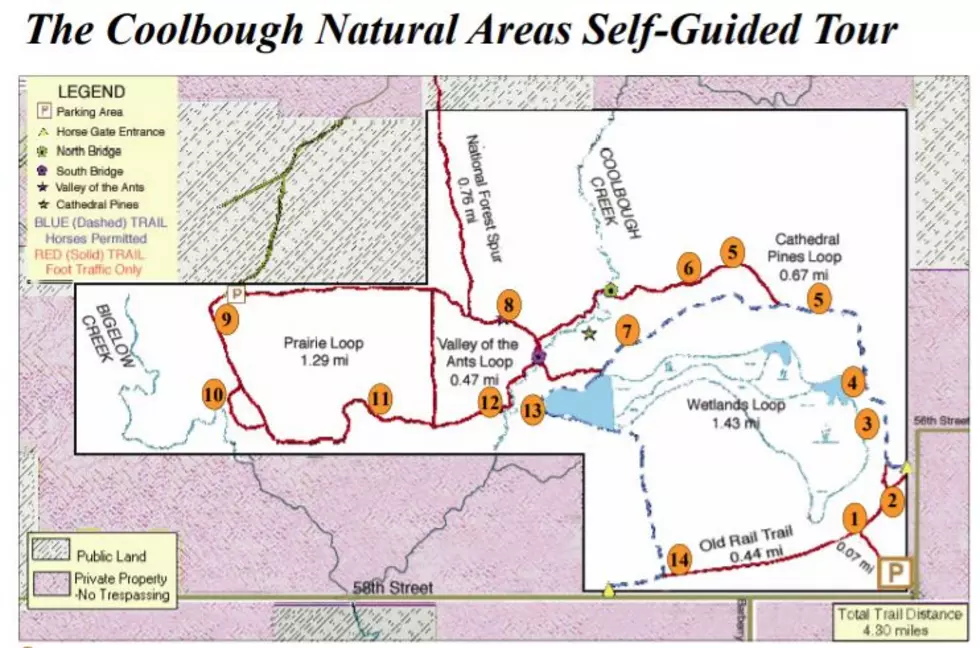
And Rademacher says it’s easy to negotiate the area, thanks to the big map just a few steps from the parking area. “It shows the different loops and some of the natural sights you can expect to find. On my first visit, I headed for a feature on the map called the ‘Valley of the Ants’. I just had to find out what that could be. There is a map at each trail junction showing where you are and what your options are. Several loops are ranging from under 2 miles to more than 3 miles. The trails are quite steep in spots and the bridges across the Coolbough Creek are narrow board footbridges. Some trail areas are open to horses.”
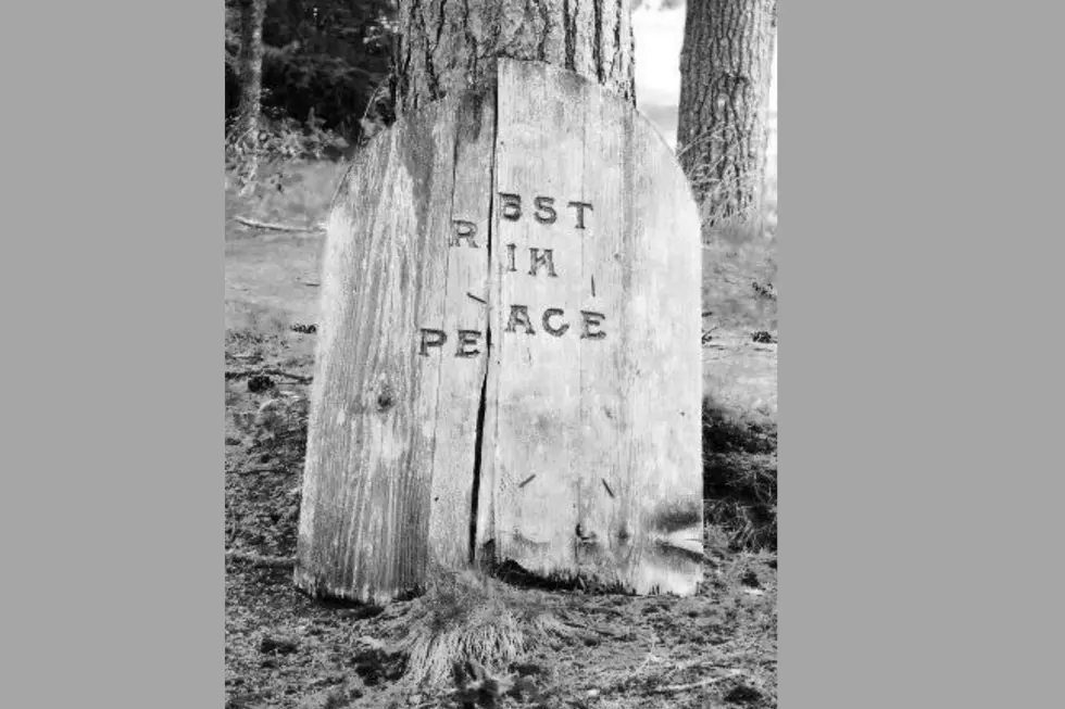
Once Rademacher dug into the history of the Coolbough Creek Natural Area, he found out why it looks the way that it does. In the late 1930s, this area was known as The Big Prairie. Accounts from a 1941 WPA project describe the area as a sandy wasteland of several square miles. “At one time this was all forest which was cleared for farmland. These conditions are great for certain grasses and wildflowers but are awful for agriculture. The enormous dunes began to form and move. The shifting dunes have blotted out trees, houses, and fields with completeness seen only in the ‘dust bowl’ of the plains. They built fences to hold back the sand, but the dunes buried those as well. Finally, restoration efforts were put in place to start reforestation. There is a story of a cemetery at the western edge of this Michigan desert with tombstones from the 1850s. I tried to find it, but had to give up when it got too dark.”
Click here for some photos of the Coolbough Nature Area from Alltrails.

MORE TO EXPLORE: Michigan Ice Caves
More From WBCKFM