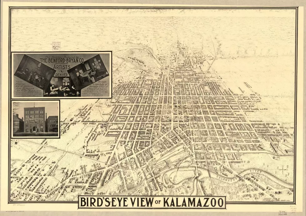
Look At This Rare 1908 Bird’s-Eye View Map Of Kalamazoo
I love finding items like this. I guess maybe I should be an American Picker. I was poking around on the Library of Congress digital collections site, and ran across this find, a 1908 drawing of a birds eye view of Kalamazoo. It's credited to the Benford-Bryan Publishing Company of Denver, of all places, and I think it's cool.
It's a wonderful reminder of how goofy the layout of the city is. You can't blame it all on the Kalamazoo River. I always joke when the topic of how strangely plotted out Kalamazoo's streets are, that there had to be bottle of whiskey involved.
The view is from east to the west and there are very familiar street names that haven't changed all that much in the 112 years since this was published. (And this is where it's great to have zoom on the screen you're looking at) The first big difference: Note that it's not Michigan Ave., it's Main St. (which, course adds to the confusion of Michigan Ave. and Kalamazoo Ave. running west into West Main, and Stadium Drive.) And there's West Street, which we call Westnedge. And Michgan Ave, is kinda sorta Stadium Drive, but WMU was only five years old at the time.
But I have even more questions, like why does Portage Road angle into downtown? Could it not have simply been plotted straight and crossed Michigan Ave (and Kalamazoo Ave. for that matter) at a 90 degree angle?
I also notice noticed the intersection of North St. and Walbridge. This map was drawn ten years before Louie's, the oldest bar in town) opened. And Coney Island downtown wasn't there either. That historic eatery dates back to 1915. But, the Gibson Guitar Company was up and running, though I don't see it mentioned specifically on this map. And look at all the railroad lines. What is now the Arcus Foundation, I've been told that rail line there, was the connection everyone took to Grand Rapids. Remember cars weren't a part of every day life like they are now. Automobiles were just getting started.
And look on the west side, K College and the "Normal School". That's Western. And the asylum south of that.
And think about it, there's no Portage, no west side of Kalamazoo. These are major business districts and they don't exist on this map. And what else don't you see? No Dollar stores on every corner, no Walgreen's, no Credit Unions. Times change.
So much interesting history. I love the Vanished Kalamazoo Facebook page, but most of that is history from the past 60 years or so. This map is almost pre-historic compared to that. I wonder what the city will look like when someone writing this story puts it together in one hundred years.

Oddest/ Silliest Kalamazoo Street Names
More From WBCKFM

